Gullies in geography are landforms that manifest as deep and narrow channels in unprotected soil. They form due to soil erosion caused by surface water runoff. They are a geographical phenomenon that can be observed in different regions in the world. They are often most associated with vegetation loss, poor land management and heavy rainfall. We look in more detail and the formation and examples of this landform as thedailyECO asks what is a gully in geography?
What are gullies in geography?
Gullies are landforms which are a result of soil erosion. Instead of infiltrating into the ground or flowing smoothly over the surface, rainwater begins to concentrate in certain spots and cause runoff. When the force of the runoff is sufficiently strong, this process drags soil particles with it. Doing so creates small furrows that become well-defined channels over time.
By definition, a gully is a geographical landform that has steep sides due to the force of the water erosion. In this way, a gully is a type of eroded channel with sharp sides that is formed by the action of water on unprotected or degraded soil.
The top of the sharp eroded sides of gullies are known as headscarps. They are formed at the head of the fluvial flow, a type of soil erosion known as headward erosion. The sides of gullies can be very short, but can range up to tens of meters in depth. They are generally not as big as valleys and both are formed by different processes.
Since the water runoff needs to have force to form a gully, they typically occur on slopes or hillsides. Areas where a gully forms are usually directly exposed to heavy rainfall and have little vegetation. This is because vegetation normally acts as a natural barrier that reduces the velocity of water and helps maintain soil structure. However, when the land has experienced deforestation, uncontrolled cultivation or unplanned urbanization, the loss of vegetation cover facilitates the onset of the erosion process that leads to the formation of gullies.
Gullies not only represent a visual alteration to the landscape, but also have significant ecological and economic consequences. They cause the loss of fertile soil, a form of environmental degradation which affects agricultural productivity and local biodiversity.
Gullies can also alter the natural direction of watercourses, cause flooding and contribute to the sedimentation of rivers, reservoirs or irrigation canals. From a social and economic perspective, gullies can damage infrastructure, such as rural roads, homes or crops. These generate high costs for their rehabilitation or control.
Once they begin to develop, gullies tend to advance and deepen if no measures are taken to stop the process of gully formation. Water running through a gully can increase in volume and velocity with each rainfall, further eroding the channel banks. This causes a gully to expand both in depth and length. In many rural areas, gully control is a key aspect of soil conservation plans.
You can discover more about how water erosion affects landforms in geography with our article asking what is a river valley?

How are gullies formed?
Gully formation is a gradual process that requires persistent fluvial action. This is driven primarily by the action of water, but is also facilitated by the nature of the soil conditions which favor erosion. Generally speaking, gullies are formed by a combination of fluvial flow and mass movement. This is the movement of water and the transportation of natural materials down slopes, respectively.
The different stages of gully formation are as follows:
- Beginning of erosion: gullies begin with surface runoff. Water begins to collect on the land surface before it overspills and forms small grooves. These narrow and shallow grooves are known as microgrooves or microchannels. Although they may seem harmless, these channels mark the beginning of the linear erosion process.
- Ripple development: with repeated rainfall and continuous runoff, these micro-ripples enlarge and become more defined rills. At this stage, water gains velocity and volume. This increases the water's ability to carry soil particles. As erosion intensifies, the rills become deeper and wider, marking the transition to more severe erosion.
- Gully formation: when the grooves exceed a certain threshold in terms of depth and width, they transform into gullies. This is the critical point at which gullies are not only more visible and destructive, but also more difficult to stop.
- Retreat and expansion: a defining characteristic of gullies is their retreat toward the top of the slope due to headward erosion. As water continues to drain, the headscarp of the gully (the highest part of the channel) shifts uphill. This retreat can lead to gullies affecting an increasing area of land, damaging farmland, roads or nearby infrastructure.
Gully formation does not occur in isolation, but depends on a combination of natural and human factors:
- Land slope: sloping areas increase the speed of water, which increases its erosive capacity.
- Soil type: sandy or highly erodible soils are more likely to be washed away by water. Soil compaction also plays a role, reducing infiltration. Read our related guide to learn more about the horizon layers of soil.
- Vegetation cover: The absence of vegetation leaves the soil unprotected, facilitating the onset of erosion.
- Land use: activities such as intensive agriculture, overgrazing, deforestation and construction without conservation measures contribute to the formation of gullies.
- Rainfall intensity: heavy and sudden rains generate greater runoff, especially in climates with intense seasonal rainfall.
You can discover another way that erosion causes the formation of landforms with our article asking what is a U-shaped glacial valley?

Examples of gullies in geography
Gullies can be found all over the world, but they do need to be in areas with lots of rainfall. This means countries with drier climates are likely to have less gullies. Although they usually appear in rural areas, they can also form in peri-urban or even urban areas if conditions permit. Some examples of gullies in nature include:
- Gullies in agricultural areas: one of the most common examples occurs in poorly managed agricultural land. This could happen when a field is plowed on a slope without following contour lines. Removal of trees or shrubs that acted as natural barriers could also allow rainwater to flow more forcefully over the soil, initiating the formation of gullies. Learn how the agriculture industry is coping with our guide to regenerative farming.
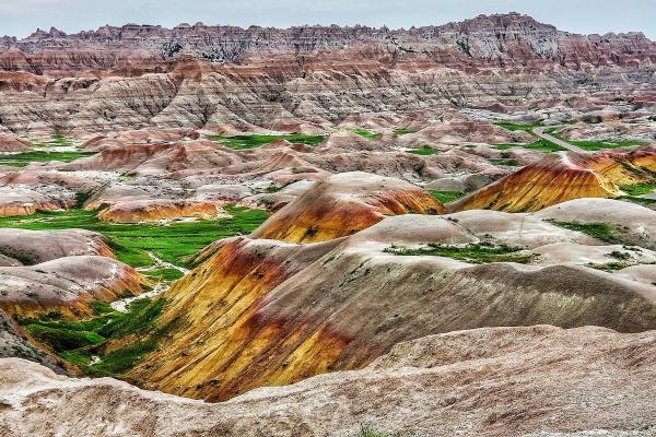
- Gullies in USA: not all states will have the same amount of gullies. This is due to their different climates and geographical formations. Some of the most prominent American gullies include those found in the Loess Bluff in Mississippi, Badlands National Park in South Dakota, Providence Canyon in Georgia and the Loess Hill areas of Nebraska, Missouri and Iowa.
- Urban or peri-urban gullies: although less common, gullies can also form in urban environments. They occur especially in neighborhoods built on slopes without adequate drainage planning.
- Gullies as a natural attraction or scientific study: in some places, gullies have become an object of study or even a tourist attraction. This is thanks to their distinctive geomorphological forms.
You can learn more about how geographical landforms are understood with our article asking what is soil science study?
If you want to read similar articles to What Is a Gully in Geography?, we recommend you visit our Ecosystems category.
- Calvo-Cases et al. (2013)Gullies and rills generated in sodic soils: Petrer (Alicante, Spain). Cuadernos de Investigación Geográfica, 37, 7–24.
https://doi.org/10.18172/cig.1244 - F. A. N., Ravelo. (2017). Geomorphology and sedimentology of badlands system in the southwest coastline of Castle Araya, Sucre State, Venezuela. Investigaciones Geográica, 92, 3-20.
https://www.elsevier.es/index.php?p=revista&pRevista=pdf-simple&pii=S0188461117300250&r=118 - JosTiino. (2014). Cárcava [Slideshow]. SlideShare.
https://es.slideshare.net/JosTiino/carcava