A river valley is a landform characterized by a depression or basin of land formed by the erosion of a natural stream of water. Valleys are common geographical features, some of which have created some of the most beautiful vistas in nature. They are also very important ecosystems for various plant and animal life, as well as the basic for a large number of human settlements. River valleys are a type of valley which differ from others, mainly in terms of their formation. They may also have distinctive landforms and shapes which set them apart. You can learn more about their formation and examples in nature as thedailyECO asks what is a river valley in geography?
What is a river valley in geography?
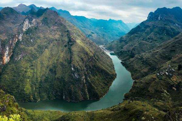
A river valley is a landform characterized by a depression or basin of land that has been formed by the erosion of a river. It is generally found between two elevations, such as mountains or hills. Depending on the slope, rock type, river flow and length of formation time, they can take on various shapes. Two of the most common examples are V-shaped an U-shaped river valleys.
To discover more background information about how water affects various landforms in geography, take a look at our article asking what is river erosion?

How is a river valley is formed?
A river valley is not formed overnight. It takes thousands and often millions of years for river erosion to create the valley and current river valleys are still continuously being shaped by river erosion, even if it is hard to see during a human lifetime. The formation of river valleys in geography follows a distinct process:
- River source in high-altitude areas: rivers are required to carry out the formation of river valleys. Rivers are streams of water which begin at an elevated area and flows down towards another body of water. In river valleys, the river must originate in mountainous or other high-altitude areas. From there, the water flows forcefully down a steep slope and causes soil erosion in the process.
- Vertical erosion in the upper valley: during the initial stage, the current is highly energetic and erodes primarily downward. This is known as vertical erosion and carves the riverbed through the abrasive action of transported materials. The result is a steep-sided, V-shaped valley. The watercourse can be straight or follow geological structures such as fractures, folds or faults, creating a more tortuous path.
- Transition to the middle valley: as the river advances and more tributaries join, the flow increases, the gradient decreases and the current slows. In this stage, processes of lateral erosion (channel widening) and sediment deposition combine. This causes the valley to widen and the river begins to meander.
- Development of the lower valley: upon reaching flatter or more level areas, the gradient is very low and sediment deposition predominates over erosion. Meanders become wider and a wide, flat floodplain can form as a result of flooding and sediment deposition.
Altitude can greatly affect different landforms in geography. Our article on the main types of relief explains more.
Parts of a river valley
From a geographical and geological perspective, river valleys are a landform made up of various parts. They include the following:
- River bed (or channel): part of the river valley through which water flows. It can be narrow and deep in mountainous areas or wide and shallow in plains.
- Banks or shores: these form the lateral edges of the riverbed. In some places, they can form ravines or steep slopes. You might be interested our related article asking what is a riverbank?
- Floodplain: a plain along the banks of a river that floods frequently. It is formed by the deposition of sediments and is characterized by dynamic environments that harbor a wealth of species.
- Meanders: sharp and winding curves formed by a river's middle and lower course. They form when the water slows down along the river's course and in floodplains where the gradient is slight.
- River terraces: former riverbed levels that have been raised by erosion or changes in river level. They can be seen as steps on the sides of the valley.
- Canyons or gorges: when erosion is very intense and vertical, the valley can transform into a canyon.
Water erosion results in various landforms in geography, not only river valleys. You can learn about another one which is not as well known with our article asking what is a wadi in geography?

Examples of river valleys
You may not be aware that some of the most famous landforms on the planet are actually river valleys or have river valleys which constitute some of their main features. Examples of some of the most important river valleys in the world include:
Amazon River Valley
It stretches across South America, passing through countries such as Brazil, Peru, Colombia, and others. It is the longest river valley in the world and contains the largest watershed on the planet. Along its course, the Amazon River flows through a vast tropical plain, forming meanders, sandbanks and an extensive network of tributaries.
Learn more about the Amazon with our article sharing the 10 longest rivers in the world.
Pilcomayo River Valley
A large river basin shared by Argentina, Bolivia and Paraguay, it forms part of the Río de la Plata system. The river originates in the foothills of the Cordillera de los Frailes in Bolivia and receives water from numerous tributaries. Its course crosses the Gran Chaco region, characterized by plains, estuaries, lagoons and riparian forest.
Nile Valley
It occupies the final section of the Nile River basin as it passes through Egypt. It's a valley averaging 19 kilometers wide from Aswan to Cairo and extends northward like a thin green ribbon across the arid African desert.
Loire Valley
Located in west-central France, the Loire Valley was formed by the action of the Loire River flowing through an area of low hills and agricultural plains. It formed wide meanders and river terraces in the process. This valley has been intensively used for agriculture and castle building, earning it UNESCO World Heritage status. It is also famous for its Loire Valley wine region which encompasses some of the most delicious European wines.

Difference between river valley and other valleys
As we have explained, a river valley is only one type of valley. Each valley type is distinguished by different factors, including the following:
- Formation: a river valley is formed by erosion and sedimentation caused by a river or stream over time. In contrast, other valleys are formed by different processes. For example, a glacial valley is formed by the movement of a glacier and rift valleys are formed by tectonic forces.
- Process: the river shapes the terrain through erosion and sediment deposition. Glaciers acts abrasively on the terrain, carving and wearing away the rocks and sediments it passes through. Glaciers also transport large amounts of sediment, creating moraines and erratics.
- Shape: river valleys are usually ‘V’ shaped in their upper reaches where the river cuts deeply into harder ground. They may become wider and U-shaped or meandering in lower reaches. Glacial valleys are U-shaped all along due to deeper and wider erosion compared to river valleys. Other valleys may have a flat-bottomed plane, such is the case with rift valleys.
- Characteristics: river valleys are common in plains, wide valleys or transition zones. They are continuously developed by the flow of river water. Glacial valleys are typical in high mountain areas or cold latitudes. Rift valleys may show faults.
Learn more about how glaciers affect landforms in other ways with our article asking what is a glacial moraine?
If you want to read similar articles to What Is a River Valley in Geography?, we recommend you visit our Environment (other) category.
- Alfaro, P., Andreu, J. M., Herrero, M. G., Martín, J. A. L., & Gómez, Á. P. (2007). An integrated study of the Earth's relief. Earth Science Education, 15(2), 112–123.