What is a Canyon in Geography?

A canyon is a geographical formation characterized by a deep and relatively narrow valley with steep walls. Canyon formation occurs primarily by the erosive action of a river over millions of years. This landform is a type of relief that can be found in different parts of the world. They are particularly useful in the study of the geography and geology of an area. This is because the erosion of the landforms required to create a canyon often reveals information that can provide unique insight into the history of the terrain. We learn more about their importance with thedailyECO as we ask what is a canyon in geography? In addition to learning about their characteristics and formation, we see examples of famous canyons from around the world.
What is a canyon in geography?
In geography, a canyon is a geological formation characterized by a deep and narrow valley with steep or nearly vertical walls. When you see some canyons, their vastness means they may not appear particularly narrow, but this is relative to their overall size.
Canyons form thanks to the action of a watercourse over millions of years. This watercourse is usually in the form of a river. Running water slowly wears away the rock of the terrain, excavating a gorge that becomes increasingly deep over time. This is a process known as fluvial erosion. It occurs gradually but steadily, primarily affecting areas with softer or more fractured rock.
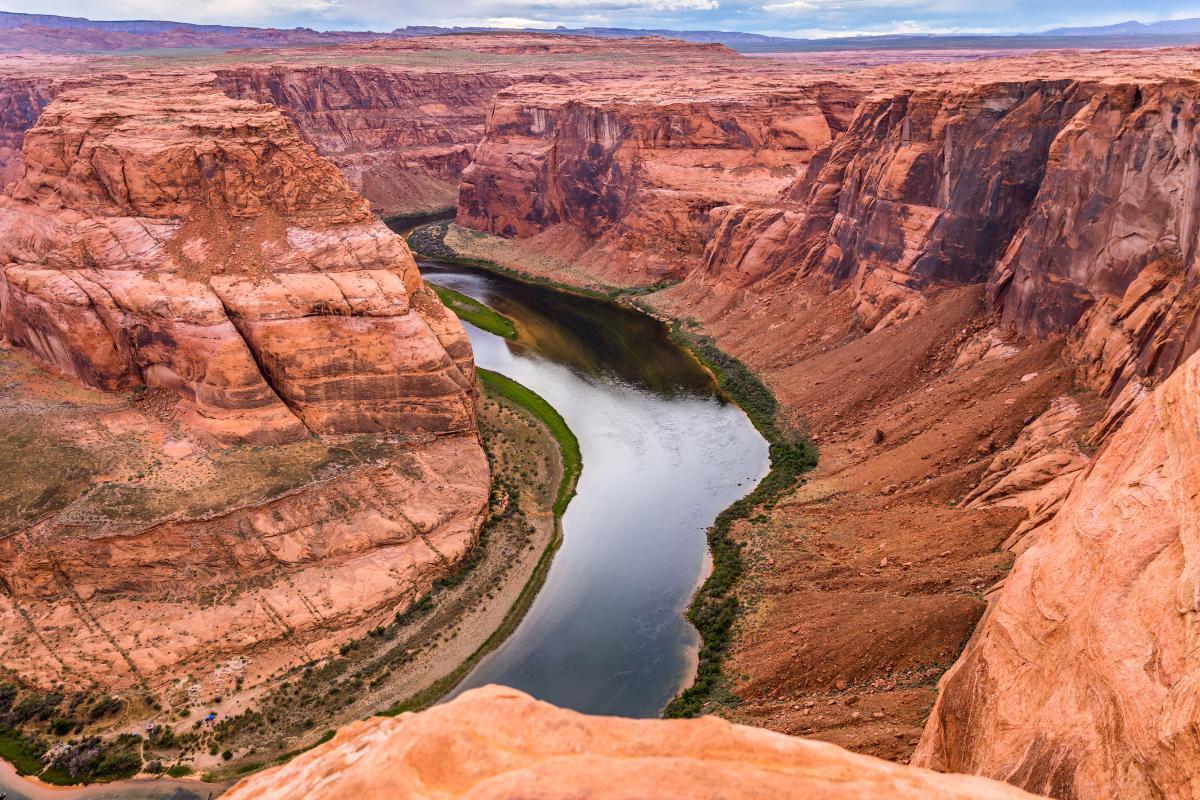
River canyons can vary greatly in size and appearance. Some are only a few meters deep and not very long. Others reach colossal dimensions, such as the Grand Canyon in the USA. This one is almost three hundred miles long and exceeds a dept of 1,600 meters deep in some places.
These gigantic landforms are not only visually impressive, but also serve as windows into Earth's geological history. As the water erodes the rock to create the tall escarpments at the sides, strata of rock are revealed that have accumulated over millions of years. These contain fossils and other geological data which allow us to know more about what came before.
You can discover more about how this process affects landforms with our article asking what is river erosion?
How is a canyon is formed?
The formation of a canyon is a slow and complex process that mainly involves the action of water over time to affect the composition of certain terrain.
- Canyon formation begins with a river flowing over a relatively smooth land surface. As the water flows, it carries with it small particles of sediment such as sand, gravel and rocks. As they are constantly rubbing against the riverbed, these particles act as a kind of natural sandpaper that progressively wears away the soil.
- This constant fluvial erosion is also known as vertical erosion. It is the primary mechanism responsible for canyon excavation. The greater the flow and velocity of the river, the more effective its cutting ability. In areas where the terrain is steeper, the water flows more forcefully and accelerates the erosion process. Over time, This results in an increasingly deeper indentation in the Earth's surface over time.
- Erosion alone isn't enough to create a large canyon. Oher factors come into play, such as the geology of the terrain. If the land is composed of layers of different types of rock, some softer than others, the river will erode the less resistant layers more quickly.
- Tectonic movements also play a role. If a region experiences tectonic uplift, the river continues to erode downward to maintain its course and further deepens the canyon.
- Another important aspect is lateral erosion. The canyon's rim is also affected by wind, rain, melting snow and other weather factors. This slowly widens the walls and changes their original shape, although the canyon retains its main ‘V’ or ‘U’, depending on its related geological characteristics.
Canyons are not the only landforms created by fluvial erosion. You can learn more with our article asking what is a wadi in geography?

Examples of canyons in geography
Canyons make up some of the most intense vistas in nature. People travel from all over the world to visit them, although there are many more which are not considered so famous. Some of the most important canyons include:
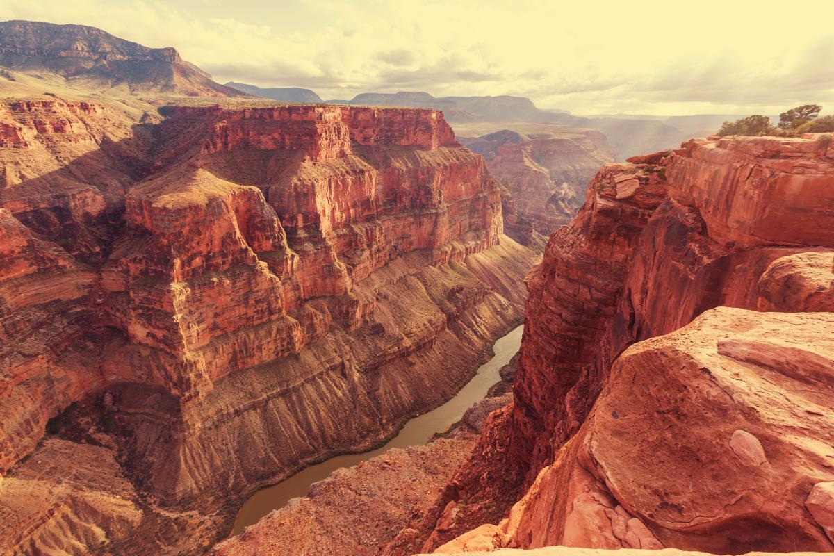
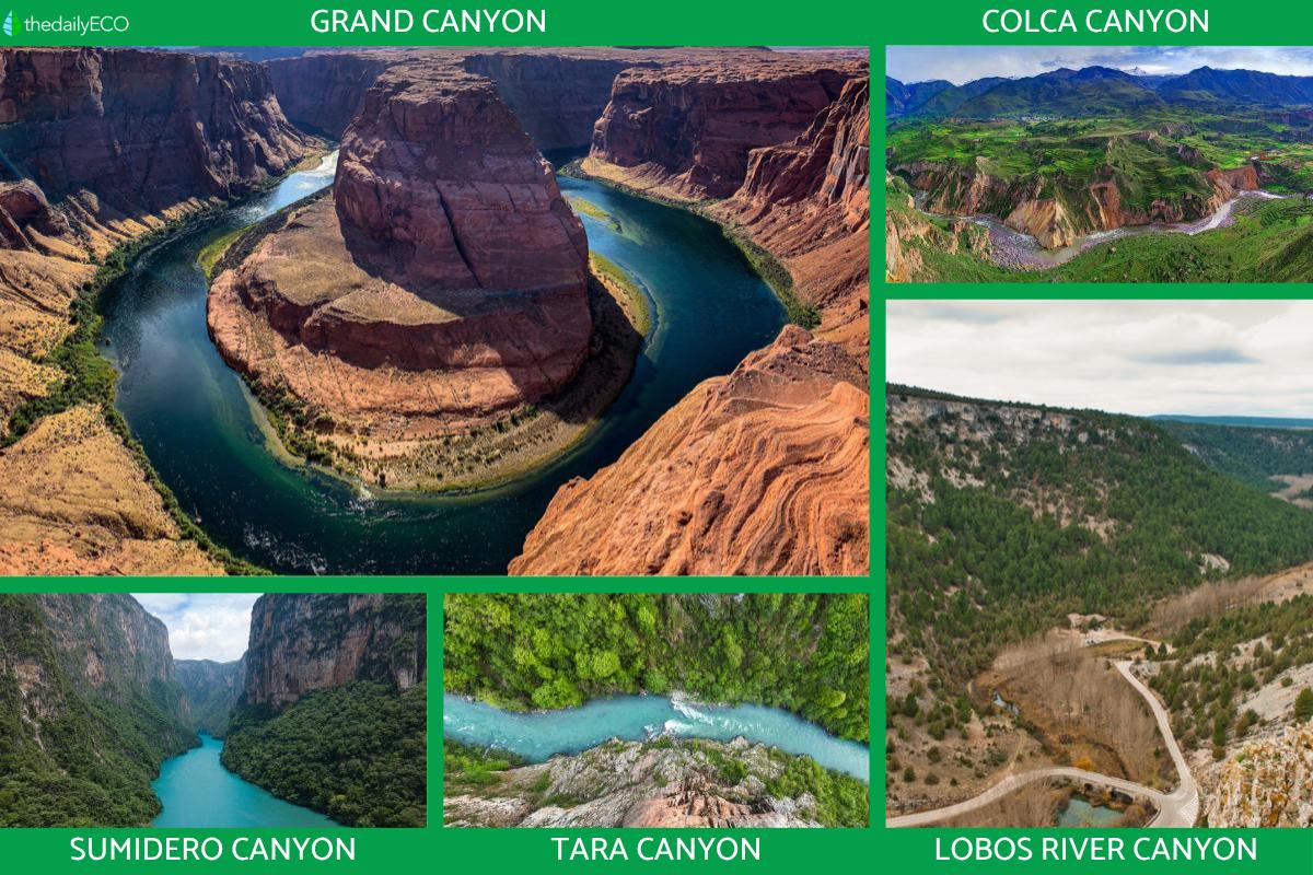
- Grand Canyon (United States): undoubtedly the most famous canyon in the world and one of the most studied. Located in the state of Arizona, it was carved by the Colorado River over more than 6 million years. It measures approximately 277 miles (446 km) long, up to 18 miles (29 km) wide and over 6,000 ft (1,800 m) deep.
- Colca Canyon (Peru): this canyon is one of the deepest on the planet, reaching nearly 2 miles (3.2 km) depth in some sections, it is twice as deep as the Grand Canyon. It is crossed by the Colca River and surrounded by majestic volcanoes and Andean villages. Discover some of the flora and fauna of the Andean region with our related guide.
- Sumidero Canyon (Mexico): located in the state of Chiapas, this canyon is a natural symbol of the country. Its vertical walls reach heights of up to 3,200 ft (1,000 m) and the Grijalva River runs through it, offering spectacular views.
- Tara Canyon (Montenegro): this European canyon is located in Durmitor National Park and is considered the deepest on the continent, with a depth reaching 4,200 ft (1,300 m).
- Lobos River Canyon (Spain): located between the provinces of Soria and Burgos, this canyon has been carved by the Lobos River through limestone formations. It's a blend of geology, nature and history, with archaeological remains and medieval buildings in its surroundings. It's also a Natural Park and particularly ideal for birdwatching.

Importance of canyons
Not just a quirk of geography, canyons can reveal much to us about our geographical history. They are also important ecosystems with specific conditions which can be home to a variety of living organisms. Canyons are important for the following reasons:
- Geological and Scientific Value: canyons offer a direct window into Earth's past. Thanks to their vertical walls, it's possible to observe strata or layers of rock that have been deposited over millions of years. Studying these formations allows geologists to understand climate evolution, tectonic movements, species extinctions and other significant geological events.
- Biodiversity and unique habitats: although some canyons are located in arid or difficult-to-access regions, many harbor unique ecosystems. The depth of the canyon can create a microclimate distinct from that at the surface, allowing for the existence of plant and animal species not found elsewhere nearby.
- Cultural and historical significance: many canyons have been sacred sites or settlements for indigenous cultures or ancient civilizations. For example, the Grand Canyon was inhabited by Native peoples such as the Hopi and Hualapai, who still maintain traditions and spiritual ties to the area today.
- Economic and tourist resource: canyons attract millions of tourists each year. Ecotourism and adventure tourism represent an important source of income for the regions where they are located.
Discover more about respecting local populations and geographical areas when vacationing with our article asking what is solidarity tourism?
If you want to read similar articles to What is a Canyon in Geography?, we recommend you visit our Environment (other) category.
- Renovables.blog. (n.d.). What are river canyons?
https://renovables.blog/agua/que-son-los-canones-fluviales/ - IngeoExpert. (2020, April 16). The Grand Canyon of the Colorado: How it was formed.
https://ingeoexpert.com/2020/04/16/el-gran-canon-del-colorado-como-se-formo/?srsltid=AfmBOoqtChlVPqt-KHPNi-e8J7x9FawluPX-1yw_54k2Cly97r6UkNhb


