What Is a Cape in Geography?

A cape is a geographical feature that is formed by an extension of land that projects into the interior of the ocean. Such capes have served for years as navigation reference points and as strategic points for the placement of lighthouses. Similarly, they are home to a rich biodiversity of plant and animal species. They can also have a significant impact on the local and regional climate by modifying marine currents, changing winds and buffering temperatures, among other effects. The formation of geographical capes can be via erosion, tectonic and sediment accumulation processes.
If you want to discover more information about what is a cape in geography? thedailyECO provides a cape definition, as well information on how it is formed and examples of famous capes from around the world.
What is a cape
In geography, a cape is an extension of land that projects into a body of water, usually the sea. This geographical feature is characterized by being a relatively narrow portion of land compared to the territory that surrounds it. Capes can occur in various shapes and sizes, from small protuberances to large extensions of land. Such land extensions usually fall under one of three types:
- Headlands: coastal landform which usually incorporates a sheer drop from a high point such as a sea cliff. This can be considered a type of promontory. Learn about the highest sea cliffs in Europe with our related guide.
- Peninsulas: a landform which is an extension of a mainland, but is covered by water on most sides. They can vary in size, but some cover very large areas (e.g. the Iberian Peninsula).
- Promontories: raised piece of land which projects into a lowland or a body of water. Most cape promontories are headlands.
Capes can have geographical, ecological and economic importance. They serve as reference points for navigation, especially when keeping track of coastal lands. They are habitats for various marine and terrestrial species, but are also often prized tourist attractions due to their impressive landscapes.

Characteristics of capes in geography
Now that we have a basic definition of a cape in geography, we can better understand them by lookin at some key cape characteristics:
- Protuberance: a cape is a prominent headland with the extension reaching out into a body of water, usually a sea. This can vary in size, but they are generally quite large.
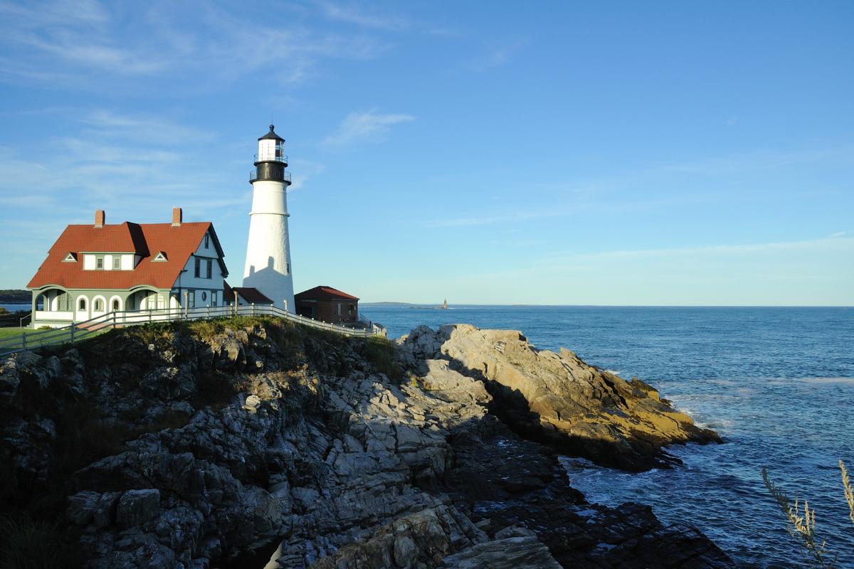
- Landmarks: for centuries, cape headlands have served as crucial landmarks for sailors. They have done so by providing improved visibility of the coast and offering protection from the many dangers of the open sea. The presence of these geographical features significantly increased the chances of survival in the event of storms or similar contingencies. For this reason, many of the most prominent capes worldwide became strategic sites for the placement of lighthouses which guided sailors in their navigation.
- Climatic influence: capes can have a significant impact on local and regional climate. Its presence can alter ocean currents and winds, modifying precipitation patterns and temperatures in adjacent areas. This climatic effect influences the distribution of terrestrial and marine ecosystems associated with the capes.
- Biodiversity: geographical capes are usually points rich in biodiversity. They usually house a large number of endemic species that are not observed anywhere else in the world. Many of them have become protected areas over the years. Some major nature reserves and national parks are types of cape.

How is a geographical cape formed?
The formation of a cape is a mainly geological phenomenon that involves both erosion and sedimentation processes. Such processes occur over long geological periods and are influenced by a combination of factors. These include the geological composition of the area, the hydrodynamic action of ocean currents and waves, as well as changes in sea level over time. Cape formations can originate in different ways:
- Erosive processes: a common way that a geographical cape is formed is through differential erosion. Rock materials of different hardness are eroded at unequal rates by the action of water. Rocks that are more resistant to wear tend to protrude into the sea, forming a cape. Areas with softer rocks tend to recede due to more intense erosion. Learn more about how coastal erosion occurs with our related guide.
- Tectonic processes: tectonic processes that uplift the land can create capes by pushing segments of the Earth's crust toward the ocean. Over time, wave erosion carves these tracts of land, giving them their characteristic shape.
- Sedimentation processes: sedimentation processes also play a crucial role in the formation of capes. Sediment transported by rivers and coastal currents can accumulate in specific areas, creating sand barriers or deposits that extend from the coast. Under favorable conditions, these deposits can be consolidated and converted into capes.
Sedimentation process are also very important in the formation of other landforms. Discover more about such process with our articles on what is a river delta and how are alluvial plains formed?

Geographical capes from around the world
As we have already stated, the world's capes constitute some of the most beautiful landscapes known in nature. Such is their beauty, they are often used for tourism. Their rich biodiversity has also led to the establishment of nature reserves and protected parks. Some of the best known capes in geography include the following:
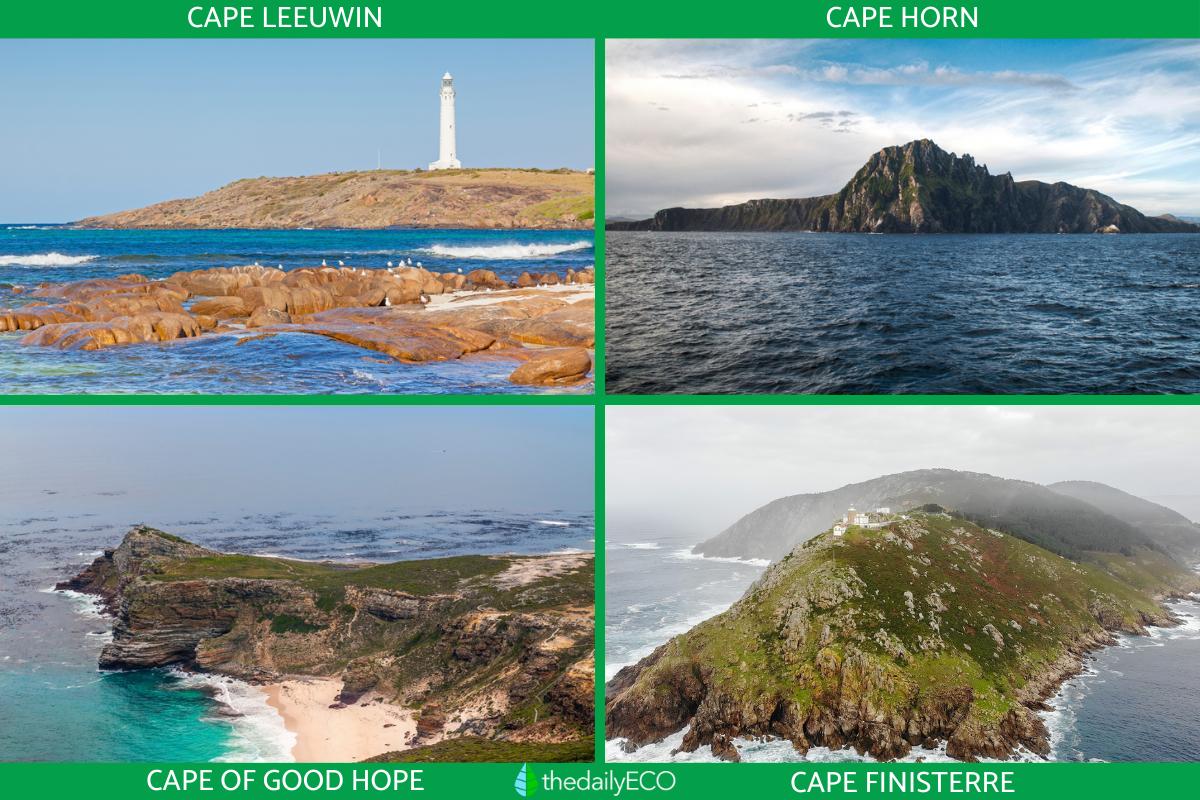
- Cape Leeuwin: marks the southwestern tip of Oceania, in Australia. This is where the Pacific and Indian Oceans meet. This is one of the three great capes of the Earth's circumnavigation, along with Cape Horn and the Cape of Good Hope. Learn about where the Pacific and the Atlantic Oceans meet with our related article.
- Cape Horn: Cape Horn is considered the southernmost point of the Americas and is located in the Magallanes region in Chile. This region represents a milestone for the conservation of biodiversity worldwide, housing a unique ecoregion of temperate forests that have not been altered. These are the sub-Antarctic or sub-polar Magellanic forests. Find out the difference between sub-polar and other types of forests.
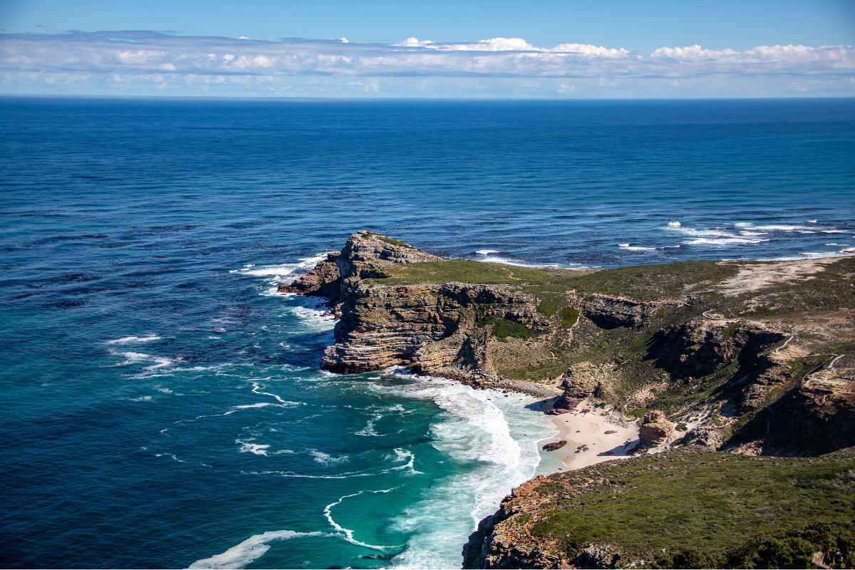
- Cape of Good Hope: the Cape of Good Hope is located at the southern tip of the African continent. It is known for its abundant plant biodiversity and the presence of many endemic species. It is recognized as the smallest but richest biological domain of flora in Africa, especially for its plant formations known as fynbos. These include three types, the proteaceae scrub, the heather scrub and the coastal scrub.
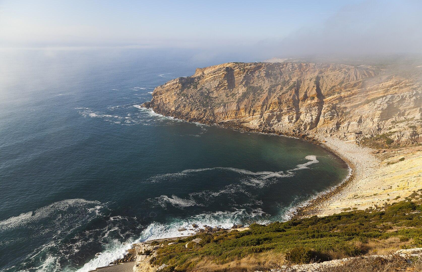
- Cape Finisterre: Finisterre is a term derived from the Latin finis terrae which means ‘end of the earth’. This is because the Romans thought that the world ended at this cape. Cape Finisterre is located on the Costa de la Muerte in Galicia, Spain and is a destination highly chosen by visitors from all over the world, being the last point on the famous walk known as the Camino de Santiago.
Now that you know what a cape in geography is and it how is formed, you may also be interested in other articles about landform creations. You can do so with our articles on the formation of an atoll and how fjords are formed.
If you want to read similar articles to What Is a Cape in Geography?, we recommend you visit our Ecosystems category.
- Aguirre, F., Squeo, FA, López, D., Buma, B., Carvajal, D., Jaña, R., & Rozzi, R. (2021). Climatic Gradients and their high influence on the terrestrial ecosystems of the Cabo de Hornos Biosphere Reserve, Chile. In Annals of the Patagonia Institute (Vol. 49). University of Magallanes.
- Aránega, JJB, de Salazar, MAC, & Bacallado Jr, JJ (2010). Western Australia and its coastal islands. Makaronesia: Bulletin of the Association of Friends of the Museum of Natural Sciences of Tenerife, 12, 22-49.


