How Do Cumulonimbus Clouds Form?

Cumulonimbus clouds are large clouds with great vertical development. Some people may wonder if cumulonimbus clouds are dangerous and the answer is that they very much can be. Although not the only type of storm cloud, they are one of the most common that appear when there are storms. They are associated with intense weather phenomena, although they can form without severe weather occurring.
Depending on the weather conditions, we can see different types of clouds appear in the sky. Not all can bring stormy weather. Clouds can be of varying size, shape and density, the latter being particularly important for potential precipitation. All clouds are the result of condensation when moist air rises and cools. In this thedailyECO article, we discover the main characteristics of cumulonimbus clouds by asking how are cumulonimbus clouds formed?
What are cumulonimbus clouds?
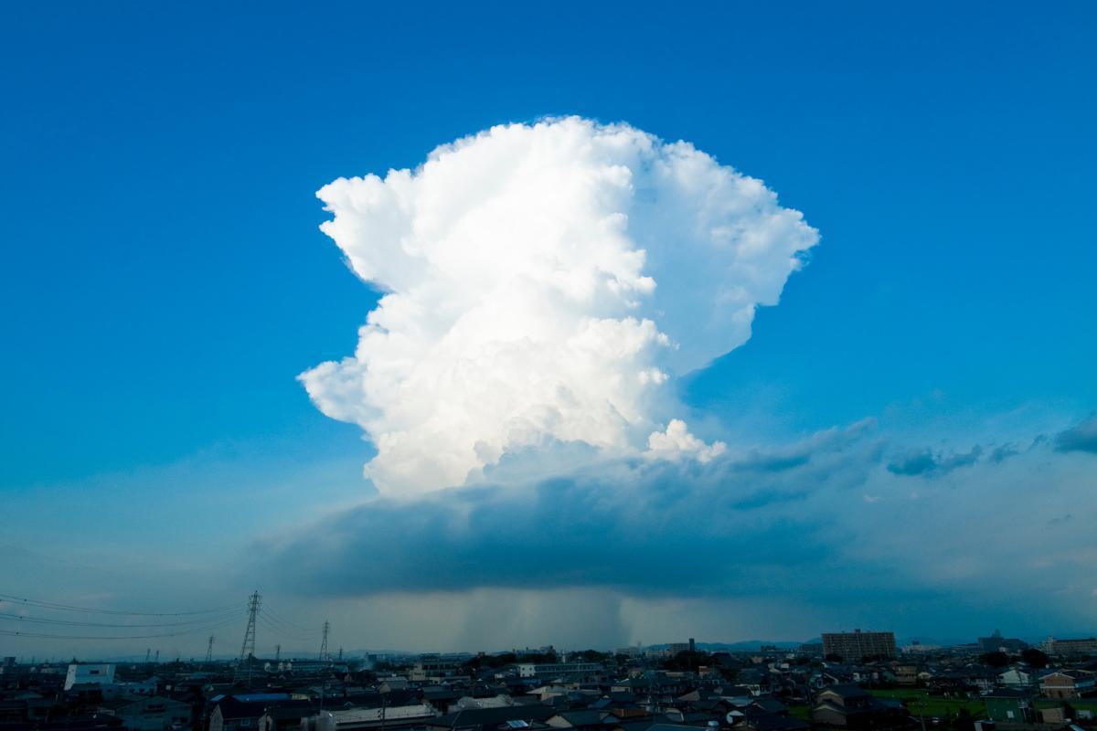
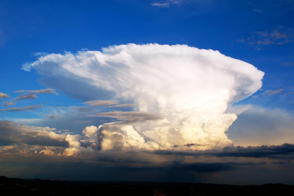
Cumulonimbus clouds are clouds with particularly tall vertical development and are associated with storms and other intense weather phenomena. While other types of clouds can also be associated with inclement weather, cumulonimbus are the largest and most powerful among all cloud types. They have a distinctive appearance with a top that often extends into an anvil shape.
These clouds are a crucial part of the weather cycle as they are associated with the release of energy in the form of rain and other weather phenomena. Although impressive in appearance, cumulonimbus clouds can also pose significant dangers in terms of adverse weather conditions. Moreover, their rapid development and sheer size make them a critical focus of meteorological studies, as understanding their formation can help in predicting severe weather. They are not just fascinating to observe, but also serve as an essential component in the Earth's atmospheric dynamics.

Characteristics of cumulonimbus clouds
Cumulonimbus clouds are distinctive types of cloud that exhibit several notable characteristics. Below are some of the main characteristics of cumulonimbus:
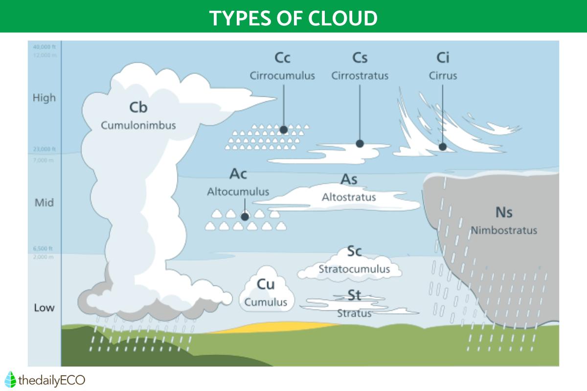
- Great height and vertical development: cumulonimbus clouds are clouds with great vertical development. They can extend through multiple layers of the atmosphere, reaching significant altitudes, sometimes even into the upper troposphere. Discover what is the troposphere and its characteristics with our related article.
- Anvil shape: a distinctive feature of cumulonimbus is the anvil shape at the top of the cloud. This formation occurs because the top of the cloud encounters a layer of the atmosphere where the temperature is low enough to cause water vapor to condense into ice. This creates a horizontal expansion that resembles an anvil in shape.
- Severe thunderstorms: cumulonimbus clouds are associated with severe weather conditions, such as thunderstorms, heavy rain, hail, and, in some cases, tornadoes. They are clouds capable of generating a variety of intense meteorological phenomena. The effect these clouds can change depending on whether they are over land or water, something we can see in the difference between water spouts and tornadoes.
- Updrafts: these clouds form from rising currents of warm, moist air. As the air rises, it cools and the water vapor contained in it condenses to form the cloud. This process is fundamental to their formation, as vigorous updrafts can lead to the rapid growth of these storm clouds.
- Rapid development: cumulonimbus can develop rapidly under favorable atmospheric conditions. This rapid development can turn seemingly harmless clouds into intense storms in a short period. This intensity can be very damaging when they are involved in the formation of violent storms such as hurricanes. Additionally, understanding the factors that contribute to this rapid growth is vital for weather forecasting and for mitigating the potential impacts of severe weather systems.
- Energy release: these clouds are associated with a significant release of energy in the form of rain, electrical discharges (lightning) and other weather phenomena. The release of this energy is what contributes to the intensity of storms associated with cumulonimbus.
- Impressive size: cumulonimbus clouds are some of the largest and most massive clouds in the sky. Their size and imposing appearance make them easily recognizable. Their vast scale can cover large geographical areas, impacting weather conditions over extensive regions.
These characteristics make cumulonimbus clouds fascinating, but they can also pose a risk due to the adverse weather conditions that often accompany their presence. Cumulonimbus is the only cloud that can produce lightning, as well as related phenomena such as St. Elmo's fire. Understanding these features is crucial for meteorologists in predicting severe weather and for the public in preparing for potential weather-related hazards.

How cumulonimbus clouds are formed
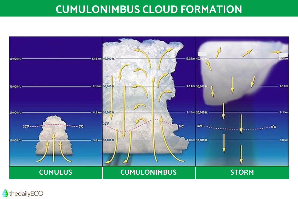
The formation of cumulonimbus clouds involves a complex process that is linked to atmospheric instability and the presence of warm, humid air. It involves the process of convection and essentially develops from smaller cumulus clouds. Here is a detailed description of the storm cloud formation from cumulonimbus cloud development:
- Surface warming: the process usually begins with heating of the Earth's surface, which can occur due to solar radiation. When the sun heats the Earth, the Earth's surface releases heat, warming the air with which it is in contact. This warming is crucial as it sets the stage for the rising of air currents that form the basis for cloud development.
- Rising of warm, moist air: warm, moist air near the surface becomes lighter and tends to rise. This rise can occur in several ways, such as through convection, where warm air rises due to its own lighter nature. The uplift of this air is a key driver in the formation of cumulus clouds, which are the precursors to cumulonimbus clouds.
- Cumulus cloud formation: as warm air rises, it cools due to decreased atmospheric pressure. When the air reaches its saturation point, where it can no longer hold water vapor, the water vapor condenses to form tiny water droplets. These droplets clump together and form cumulus clouds, which are white, fluffy clouds.
- Vertical development: under certain conditions, cumulus clouds can undergo rapid vertical development. This occurs when atmospheric instability is significant, allowing strong updrafts to lift clouds to higher altitudes. This vertical growth is what transforms these fluffy clouds into towering cumulonimbus clouds.
- Transition to cumulonimbus: as updrafts continue to lift clouds, cumulus clouds may develop further and transform into cumulonimbus. This process involves the formation of an increasingly larger and taller cloud column, one capable of producing severe weather.
- Anvil-shaped top: the top of cumulonimbus reaches altitudes where the temperature is low enough to freeze water droplets into ice crystals. This gives rise to the characteristic anvil shape at the top of the cloud. This shape is often seen spreading out horizontally, marking the cloud's limit in the troposphere.
- Severe weather events: mature cumulonimbus columns are associated with severe weather events, such as thunderstorms, heavy rain, hail, and tornadoes. This is due to the strong updrafts and associated energy release. The intense energy dynamics within these clouds can result in dramatic weather changes in short periods.
In summary, cumulonimbus clouds form from cumulus clouds that undergo significant vertical development driven by strong updrafts and unstable atmospheric conditions. This process creates massive clouds that can cause severe weather conditions. It's interesting to note that the lifecycle of these clouds can vary based on environmental conditions, influencing both their formation and dissipation.
Although cumulonimbus clouds almost always form from cumulus clouds, there are rare circumstances when cumulonimbus clouds develop directly. This is when the rapid and intense vertical development occurs due to strong atmospheric instability, often being exacerbated by something that gives it more lifting movement. This could be a mountain or cold front, such as what occurs with the foehn effect. Such phenomena illustrate the dynamic nature of weather systems and the various factors that can influence cloud formation.

How do cumulonimbus clouds disappear?
Now we know how storm clouds form, it is important to know how they disappear. As with all types of cloud, cumulonimbus clouds do not stay around forever. There are various reasons for cumulonimbus storm clouds to disappear which include the following:
- Precipitation: once the precipitation is released, the cumulonimbus cloud loses its weight and the storm cloud can dissipate. This precipitation is often in the form of rainfall, as well as sleet and hail when the temperatures are sufficiently cold. The heavier the storm cloud, the greater the potential for a torrential downpour. In many cases, the release of precipitation marks the beginning of the end for these towering clouds.
- Atmospheric change: as the formation of cumulonimbus clouds is due to atmospheric changes, so too is their dispersal. Storm clouds will disappear once factors such as air pressure, humidity, and temperature change sufficiently. These shifts can stabilize the atmosphere, leading to the gradual dissipation of the cloud.
- End of day: when the sun sets, the change in temperature can be enough to cause the cumulonimbus cloud to disappear. This is because the heat of the sun goes away with it. The cooling effect of nightfall often reduces the convection currents necessary to sustain these large clouds.
- Wind shear: sometimes, changes in wind speed and direction at different altitudes can disrupt cumulonimbus clouds. This wind shear can effectively tear the cloud apart, leading to its dissipation. Understanding how these various mechanisms contribute to cloud dissipation can be crucial for weather forecasting and managing the risks associated with severe weather.
You can learn more about the different phenomena associated with clouds in our article on what causes sun halos?
If you want to read similar articles to How Do Cumulonimbus Clouds Form?, we recommend you visit our Meteorological phenomena category.


